In today’s rapidly evolving world of land development and surveying, technological advancements are transforming the way data is collected, analyzed, and utilized; a leading aerial survey company based in New Zealand. Combining the power of cutting-edge drone technology with years of expertise, Horizon provides innovative, efficient, and sustainable solutions to a wide range of industries, including real estate, civil engineering, construction, and environmental conservation.
Why Aerial Surveying Matters?
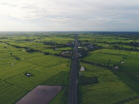
Aerial surveying is a revolutionary technique that uses unmanned aerial vehicles (UAVs), or drones, equipped with high-resolution cameras and other sensors to capture detailed imagery and geographic data from the air. This modern surveying method offers numerous advantages over traditional land-based surveying, such as speed, accuracy, and cost-effectiveness. For example, drones can cover large areas quickly, providing high-resolution data that would take much longer to collect on foot. Additionally, aerial surveys can be conducted in hard-to-reach or hazardous locations, reducing the need for human presence in potentially dangerous areas.
Using drones equipped with high-tech cameras, LiDAR (Light Detection and Ranging), and GPS systems, Horizon’s team can create precise 3D models, orthophotos, and topographic maps for their clients. This technology not only enhances the speed and accuracy of the data collection but also improves the overall quality of results.
The Unique Approach of Horizon Surveying & Land Development
As a premier aerial survey company offers a wide array of services, all underpinned by their use of the latest drone technology. Their services cater to industries such as construction, urban planning, and environmental management, providing valuable insights and data that are essential for informed decision-making. Here’s what makes Horizon stand out:
1. State-of-the-Art Technology
At Horizon, staying ahead of technological trends is crucial to their business. They use advanced drone technology to conduct high-precision surveys that deliver accurate, detailed data. Equipped with state-of-the-art cameras and sensors, these drones can capture 3D imagery, topographical features, and even real-time data that can be analyzed and processed to meet specific project requirements.
One of the key features of this technology is the ability to create detailed topographic maps and 3D models of the surveyed land. These maps and models help clients visualize their project sites, understand elevation changes, and make informed decisions on land usage, infrastructure development, and resource management.
2. Comprehensive Surveying Services
While Horizon is primarily known for its aerial surveying expertise, the company also offers a comprehensive suite of services to support the land development process from start to finish:
3. Focus on Sustainability
As aerial survey company is committed to incorporating sustainability into every aspect of their work. Using drones and other technology significantly reduces the need for manual labor and minimizes the environmental footprint of surveying activities. Additionally, Horizon takes great care to ensure that their surveying practices adhere to New Zealand’s environmental regulations, ensuring that every project preserves the natural beauty and ecological balance of the land.
The company’s commitment to sustainable land development practices is evident in the way they approach each project. They consider the long-term impact on local ecosystems and work with clients to create environmentally conscious designs and solutions.
4. Local Expertise and Regional Knowledge
Another factor that sets Horizon apart is their deep local knowledge. With offices in Red Beach and Mangawhai Heads, the Horizon team is familiar with the unique challenges and regulations that come with land development in New Zealand. Whether it’s dealing with coastal areas, mountainous terrain, or urban sites, Horizon has the expertise to tackle any project, regardless of complexity.
Horizon’s local expertise also allows them to provide personalized service that’s tailored to the needs of each client. They understand the intricacies of local zoning laws, environmental regulations, and the community’s development goals, ensuring that all projects comply with necessary legal frameworks and are developed in a way that benefits both the client and the surrounding community.
5. A Client-Centric Approach
Horizon Surveying & Land Development places a strong emphasis on building long-lasting relationships with clients. They pride themselves on their transparent, “no surprises” approach, ensuring that clients are kept informed and updated throughout the project’s lifecycle. Whether it’s providing regular progress reports, answering questions, or offering expert advice, Horizon is always ready to support their clients every step of the way.
Their team of surveyors, planners, and designers is committed to delivering high-quality results that meet or exceed client expectations. Horizon’s dedication to client satisfaction is a testament to their commitment to service excellence and reliability.
Real-World Application: Whangaripo Valley Road Project
A perfect example of Horizon’s expertise is their work on the Whangaripo Valley Road project. In this project, Horizon employed their aerial surveying technology to gather data on a large and challenging site. By using drones to capture aerial imagery and 3D models, Horizon was able to create a comprehensive understanding of the landscape, which was then used to plan the road construction.
This project demonstrated the clear advantages of aerial surveying over traditional methods. By utilizing drones, Horizon was able to collect data faster, more accurately, and at a lower cost, ensuring the project’s success while minimizing disruption to the environment.
Why Choose Horizon Surveying & Land Development?
Choosing the right aerial survey company can make a significant difference in the success of your land development project.


Leave a Reply